Rapid CAT Response™

$2,500.00

ROAR Rapid CAT Response™ delivers fast, defensible aerial documentation for catastrophic weather events. We deploy within hours of major hail, wind, tornado, and flood events to capture high-resolution imagery, orthomosaics, and site-specific damage documentation for insurance carriers, public adjusters, municipalities, and landowners.

Our CAT operations are built for scale—covering large geographic areas efficiently while maintaining strict data integrity, chain-of-custody, and clear deliverables that support claims, assessments, and recovery decisions. From residential neighborhoods to agricultural land and critical infrastructure, ROAR provides clear aerial intelligence when time matters most.

CAT Pricing Details

CAT Response services are priced on an event and deployment basis rather than per property or per acre. Pricing reflects rapid mobilization, operational availability, and the ability to cover multiple sites efficiently during high-volume storm events. Final cost is determined by deployment duration, travel distance, area coverage, and requested deliverables. Multi-day and multi-site deployments may be quoted at adjusted rates.

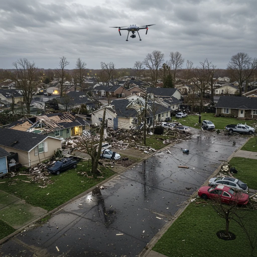
ROAR Rapid CAT Response™ provides fast, scalable aerial documentation following catastrophic weather events, including hail, tornadoes, straight-line wind, and flooding. Our CAT operations are designed to support insurance adjusters, public agencies, and property stakeholders who need clear, defensible imagery when ground access is limited or timelines are compressed.

Deployments focus on wide-area situational awareness and site-specific documentation. We capture high-resolution nadir and oblique imagery, mapped overviews, and geo-referenced damage visuals that help identify impact patterns, prioritize inspections, and support claim and recovery decisions.

ROAR operates under FAA Part 107 and maintains professional data-handling and documentation standards appropriate for insurance and post-incident use. Deliverables are provided in organized, clearly labeled formats suitable for claim files, reports, and internal review. When required, rapid turnaround options are available to meet catastrophe-driven timelines.

Typical CAT use cases include residential and commercial property documentation, agricultural land and crop damage assessment, municipal and infrastructure impact surveys, and pre- or post-repair condition documentation. Services may be performed on a per-site, per-day, or event-based basis depending on scope and deployment needs.

ROAR Rapid CAT Response™ is intended to complement—not replace—on-the-ground inspections by providing aerial context and objective visual records that improve efficiency, safety, and decision-making during high-volume storm response operations.

ROAR provides aerial documentation and mapping services only. We do not perform claim determinations, coverage decisions, or engineering evaluations.